![](/images/other/stat-length.png)
![Tocht Stappen Le Tampon - La Réunion - Grand Bassin - Photo](https://media.geolcdn.com/t/1900/400/ext.pjpeg?maxdim=2&url=https%3A%2F%2Fservices.sitytrail.com%2FGeolivesWS%2FDownloadMedia.ashx%3FTrailID%3D339519%26Media%3Da0d5c9f6-1bc3-4502-9e69-96bbcc409475.jpg)
La Réunion - Grand Bassin
olive2b
Gebruiker
![Lengte](/images/other/stat-length.png)
Lengte
5,8 km
![Max. hoogte](https://static1.geolcdn.com/siteimages/upload/files/1508320355ic_sort_altitude_max_24dp.png)
Max. hoogte
1402 m
![Positief hoogteverschil](https://static1.geolcdn.com/siteimages/upload/files/1508320355ic_sort_den_pos_24dp.png)
Positief hoogteverschil
111 m
![Km-Effort](/images/other/stat-length.png)
Km-Effort
10 km
![Min. hoogte](https://static1.geolcdn.com/siteimages/upload/files/1508320355ic_sort_altitude_min_24dp.png)
Min. hoogte
599 m
![Negatief hoogteverschil](https://static1.geolcdn.com/siteimages/upload/files/1508320355ic_sort_den_neg_24dp.png)
Negatief hoogteverschil
902 m
![Boucle](https://static1.geolcdn.com/siteimages/upload/files/16400158638029165_repeat_loop_refresh_sync_direction_icon.png)
Boucle
Neen
Datum van aanmaak :
2016-03-09 00:00:00.0
Laatste wijziging :
2016-03-09 00:00:00.0
![Stappen](https://static1.geolcdn.com/sitytour/trail-icons/101.png)
2h56
Moeilijkheid : Medium
![Scan deze QR-code om de tocht te openen in de SityTrail-applicatie](https://capi.geolives.com/qq0zvz2zws4bq2lad0pu/sitytour/trails/339519/qr.png?size=200)
Gratisgps-wandelapplicatie
Over ons
Tocht Stappen van 5,8 km beschikbaar op Réunion, Onbekend, Le Tampon. Deze tocht wordt voorgesteld door olive2b.
Beschrijving
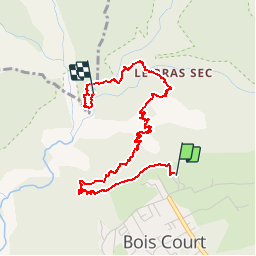
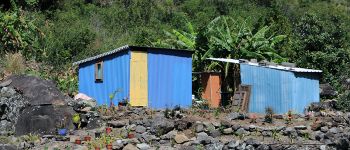
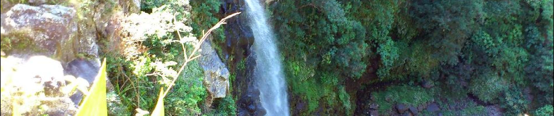
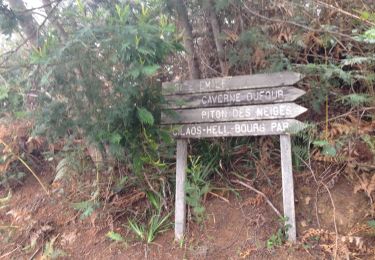
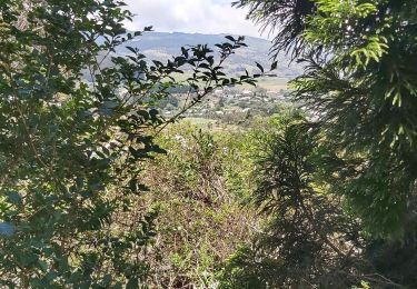
Trajet aller. Le circuit (en descente principalement) commence au départ du Belvédère de Bois Court. Vue plongeante sur Grand Bassin, et la cascade le voile de la mariée. A mi-chemin, un ravitaillement en eau est possible.
POI's
Plaatsbepaling
Land:
France
Regio :
Réunion
Departement/Provincie :
Onbekend
Gemeente :
Le Tampon
Locatie:
Unknown
Vertrek:(Dec)
Vertrek:(UTM)
348182 ; 7655987 (40K) Z.
Opmerkingen
Wandeltochten in de omgeving
![Tocht Stappen Entre-Deux - La Réunion - Le Dimitile (aller-retour) par le sentier de la chapelle. - Photo](https://media.geolcdn.com/t/375/260/ext.jpg?maxdim=2&url=https%3A%2F%2Fservices.sitytrail.com%2FGeolivesWS%2FDownloadMedia.ashx%3FTrailID%3D449274%26Media%3Dfix__20150724090014.jpg)
![Stappen Stappen](https://static1.geolcdn.com/sitytour/trail-icons/101.png)
La Réunion - Le Dimitile (aller-retour) par le sentier de la chapelle.
Stappen
Medium
(1)
Entre-Deux,
Réunion,
Onbekend,
France
![](/images/other/stat-length.png)
11,9 km | 24 km-effort
5h 29min
![](https://static1.geolcdn.com/siteimages/upload/files/16400158638029165_repeat_loop_refresh_sync_direction_icon.png)
Ja
![Tocht Stappen Le Tampon - Grand Bassin à partir de Bois Court - Photo](https://media.geolcdn.com/t/375/260/ext.jpg?maxdim=2&url=https%3A%2F%2Fmedia.geolcdn.com%2Ff%2F546c7d2f-db6d-45ed-ad24-b006fb8e00d4.jpg)
![Stappen Stappen](https://static1.geolcdn.com/sitytour/trail-icons/101.png)
Grand Bassin à partir de Bois Court
Stappen
Moeilijk
(1)
Le Tampon,
Réunion,
Onbekend,
France
![](/images/other/stat-length.png)
9,5 km | 22 km-effort
4h 23min
![](https://static1.geolcdn.com/siteimages/upload/files/16400158638029165_repeat_loop_refresh_sync_direction_icon.png)
Ja
![Tocht Stappen Entre-Deux - boucle citrons galets - Photo](https://media.geolcdn.com/t/375/260/ext.jpg?maxdim=2&url=https%3A%2F%2Fservices.sitytrail.com%2FGeolivesWS%2FDownloadMedia.ashx%3FTrailID%3D361878%26Media%3D20141111140014.jpg)
![Stappen Stappen](https://static1.geolcdn.com/sitytour/trail-icons/101.png)
boucle citrons galets
Stappen
Medium
(1)
Entre-Deux,
Réunion,
Onbekend,
France
![](/images/other/stat-length.png)
17,4 km | 33 km-effort
6h 50min
![](https://static1.geolcdn.com/siteimages/upload/files/16400158638029165_repeat_loop_refresh_sync_direction_icon.png)
Ja
![Tocht Stappen Entre-Deux - Jacky Inard jusqu'à la 1ere echelle - Photo](https://media.geolcdn.com/t/375/260/ext.jpg?maxdim=2&url=https%3A%2F%2Fmedia.geolcdn.com%2Ff%2F52d3adaa-62d7-4e1e-b244-a796f216ad55.jpg)
![Stappen Stappen](https://static1.geolcdn.com/sitytour/trail-icons/101.png)
Jacky Inard jusqu'à la 1ere echelle
Stappen
Zeer moeilijk
Entre-Deux,
Réunion,
Onbekend,
France
![](/images/other/stat-length.png)
17 km | 37 km-effort
8h 19min
![](https://static1.geolcdn.com/siteimages/upload/files/16400158638029165_repeat_loop_refresh_sync_direction_icon.png)
Ja
![Tocht Trail Le Tampon - Voile de la Mariée par Grand Bassin - Photo](https://media.geolcdn.com/t/375/260/ext.jpg?maxdim=2&url=https%3A%2F%2Fmedia.geolcdn.com%2Ff%2F5427d8f3-02fa-4d1e-bfb5-4fd763fbd394.jpg)
![Trail Trail](https://static1.geolcdn.com/sitytour/trail-icons/104.png)
Voile de la Mariée par Grand Bassin
Trail
Moeilijk
Le Tampon,
Réunion,
Onbekend,
France
![](/images/other/stat-length.png)
10,4 km | 25 km-effort
3h 20min
![](https://static1.geolcdn.com/siteimages/upload/files/16400158638029165_repeat_loop_refresh_sync_direction_icon.png)
Ja
![Tocht Te voet Le Tampon - 3 pitons à Bourg Murat - Photo](https://media.geolcdn.com/t/375/260/ext.jpg?maxdim=2&url=https%3A%2F%2Fmedia.geolcdn.com%2Ff%2F970bad91-7bf9-4096-b52f-d8b7555be2f2.jpg)
![Te voet Te voet](https://static1.geolcdn.com/sitytour/trail-icons/100.png)
3 pitons à Bourg Murat
Te voet
Medium
Le Tampon,
Réunion,
Onbekend,
France
![](/images/other/stat-length.png)
12,4 km | 16,4 km-effort
Onbekend
![](https://static1.geolcdn.com/siteimages/upload/files/16400158638029165_repeat_loop_refresh_sync_direction_icon.png)
Ja
![Tocht Stappen Le Tampon - grand bassin mollaret piton rando - Photo](https://media.geolcdn.com/t/375/260/ext.jpg?maxdim=2&url=https%3A%2F%2Fstatic1.geolcdn.com%2Fsiteimages%2Fupload%2Ffiles%2F1553511878bg_sport_marche.png)
![Stappen Stappen](https://static1.geolcdn.com/sitytour/trail-icons/101.png)
grand bassin mollaret piton rando
Stappen
Moeilijk
(1)
Le Tampon,
Réunion,
Onbekend,
France
![](/images/other/stat-length.png)
18,9 km | 37 km-effort
7h 30min
![](https://static1.geolcdn.com/siteimages/upload/files/16400158638029165_repeat_loop_refresh_sync_direction_icon.png)
Ja
![Tocht Stappen Le Tampon - Murat nez de bœuf - Photo](https://media.geolcdn.com/t/375/260/ext.jpg?maxdim=2&url=https%3A%2F%2Fstatic1.geolcdn.com%2Fsiteimages%2Fupload%2Ffiles%2F1553511878bg_sport_marche.png)
![Stappen Stappen](https://static1.geolcdn.com/sitytour/trail-icons/101.png)
Murat nez de bœuf
Stappen
Heel gemakkelijk
(1)
Le Tampon,
Réunion,
Onbekend,
France
![](/images/other/stat-length.png)
15,9 km | 23 km-effort
5h 23min
![](https://static1.geolcdn.com/siteimages/upload/files/16400158638029165_repeat_loop_refresh_sync_direction_icon.png)
Ja
![Tocht Stappen Le Tampon - Coteau Maigre - Photo](https://media.geolcdn.com/t/375/260/ext.jpg?maxdim=2&url=https%3A%2F%2Fstatic1.geolcdn.com%2Fsiteimages%2Fupload%2Ffiles%2F1553511878bg_sport_marche.png)
![Stappen Stappen](https://static1.geolcdn.com/sitytour/trail-icons/101.png)
Coteau Maigre
Stappen
Moeilijk
(2)
Le Tampon,
Réunion,
Onbekend,
France
![](/images/other/stat-length.png)
16,8 km | 26 km-effort
5h 26min
![](https://static1.geolcdn.com/siteimages/upload/files/16400158638029165_repeat_loop_refresh_sync_direction_icon.png)
Ja
le grand bassin